Assessing physical habitat: seeking the Holy Grail of river monitoring
17 March, 2026
by Paul Raven and Malcolm Newson
FBA Honorary Fellow Paul Raven was Head of Conservation and Ecology at the Environment Agency during 1996-2011. He led development of the River Habitat Survey, notable for producing the first UK-wide assessment of the physical state of rivers. He co-authored, with Nigel Holmes, the award-winning book Rivers: a natural and not-so natural history.
Malcolm Newson is Emeritus Professor at Newcastle University; in his 60s he became full-time Director of Tyne Rivers Trust for ten years – a decade spent close up to citizen science. His 200 publications on rivers helped form the evidence base for the Catchment Based Approach and he is co-author of the Guidebook of Applied Fluvial Geomorphology (Thomas Telford, 2010).
Here we are delighted to join Paul and Malcolm for a think piece with a difference, as this invites you to participate in some river-related observational tests, to see if you are able to identify from the photographs included evidence of specific physical habitat features.
Introduction
‘Holy Grail’ is a term used to describe an object or goal that is sought after but very difficult to find (Google AI). Searching for a credible, repeatable and practical method for assessing the physical dimension of river health has been our Holy Grail, occupying on and off, both our professional (and retirement) lives since the 1980s and 1990s. The quest has been satisfying and frustrating in equal measure, reflecting its pioneering nature but inherent technical difficulties, only a few of which can benefit from emerging sophisticated methodologies.
This article outlines a recent paper of ours (1) that advocates two fundamental principles. First: identifying and tackling multiple stressors is the only way forward for strategic and sustainable river management and recovery in the context of population pressures and climate change. Second: a combination of clear purpose, scientific credibility, practical applicability and professional expertise and experience is required for successfully deploying a relatively new and intellectually complex methodology.
It is self-evident that physical habitat features and the natural fluvial processes that shape them are essential components of river ecosystem health. Impoverished habitat and regulated flow will not support the full range of ‘natural’ river plant and animal communities even if water quality is unimpaired.
Measuring river health
A true measure of river health needs to calibrate, as far as possible, the effect of multiple stressors acting on water quality, quantity and physical parameters. River health measured in terms of ‘departure from naturalness’ is a key principle of the European Water Framework Directive (WFD), adopted by Member States in 2000 and which remains the core driver for river management in the UK. The FBA’s ‘Priority Habitats’ project addresses the assessment of such departures. Our quest to incorporate physical character in river quality assessment pre-dated the WFD and was grounded in various pioneering research and operational initiatives instigated in the 1980s and 1990s.
Historically, river quality was monitored and classified using indicators of organic and other toxic pollution. Water samples and aquatic macroinvertebrates are routinely collected at many hundreds of sites across the river network to assess and monitor chemical and biological water quality for state of environment reporting and pollution control compliance purposes. Sampling protocols and laboratory-based analytical methods were scientifically calibrated to ensure chemical and biological results were sufficiently robust to provide court-level evidence in case of prosecution.
Recently, citizen science has been successfully recruited to help take water and biological samples; a notable example, familiar to many FBA members, is the Riverfly partnership (https://riverflies.org). Development of citizen science water quality monitoring was largely in response to reduced monitoring and enforcement effort by statutory agencies (caused by funding cuts), public outcry over serious pollution incidents and a willingness for local activists to intervene. Together with the Rivers Trusts, the FBA has been at the forefront of this effort, which has political and wider public support.
Assessing river health through physical habitat and fluvial processes
In contrast, physical habitat and understanding fluvial processes within the catchment has been a neglected part of river health assessment. Professional fluvial geomorphologists are scarce, both in academia and river management organisations; in the USA, experience of unintended consequences when not involving such expertise bears witness to the dangers of ‘extra-mural knowledge’. The legal imperative for monitoring and ability to prosecute damaging action is very limited, with the River Lugg SSSI (Site of Special Scientific Interest) dredging incident demonstrating the point. In addition, parameters for measuring ‘departure from naturalness’ and associated ‘quality’ proxies are much more difficult than for water chemistry or biological assemblage equivalents; it is not ‘pass’ or ‘fail’.
Although much essential contextual landform, riverscape and habitat information can be gleaned from satellite and drone aerial photography (advances in AI interpretation technology continue apace) there is no substitute for field survey for ground truth and interpretation. The technical skill set required for credible, repeatable observational field survey is considerable. This is because of the complexity and often subtle variations of morphological features across different types of rivers and the fact that the character of individual catchments has been forged by a unique sequence of natural (particularly post-glacial) and un-natural (human intervention) history. Field data collection for physical features is much more complicated and time-consuming than taking a chemical or biological water sample for laboratory analysis, whilst the non-empirical nature of interpretation is inevitably less precise.
The single biggest difficulty in assessing physical ‘quality’ and ‘naturalness’ is the fundamental problem of scale, since both features and fluvial processes that form them act at various scales (microhabitat to landscape) and over different timescales. The immediate problem is trying to reconcile a ‘snapshot’ approach (akin to water quality sampling but using a suitable sample unit length) to assess habitat diversity and artificial modification at a ‘site’ with the continuum of fluvial processes (natural and regulated) acting throughout the river length. Technical trade-offs and compromises are inevitable; and protocols for data collection and subsequent interpretation are predominantly based on ‘expert opinion’ rather than empirical data.
Moreover, since each river is different in terms of catchment land-use history, interpretation and classification is not straightforward. Textbook river typology may work in semi-natural expanses of uninhabited or sparsely inhabited parts of the world but certainly not in Britain where centuries of agricultural and industrial development have fundamentally and in many cases irrevocably changed riverscapes. ‘Cookbooks’ based on river classifications or typologies therefore offer only limited guidance.
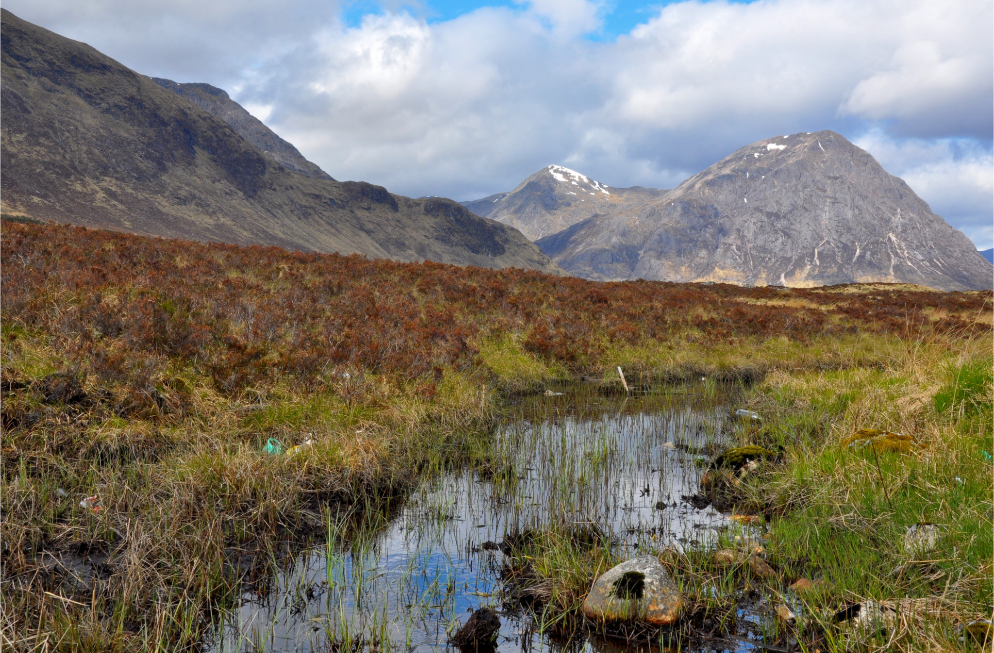
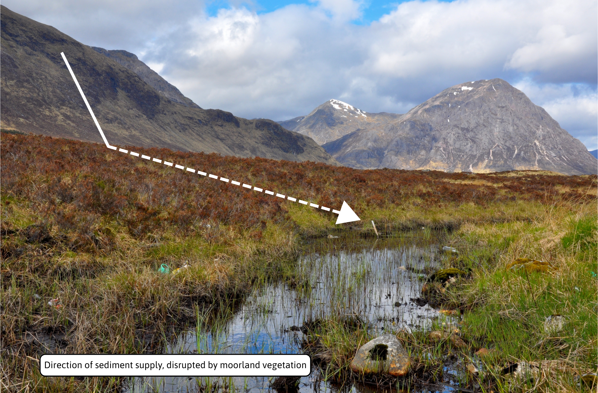
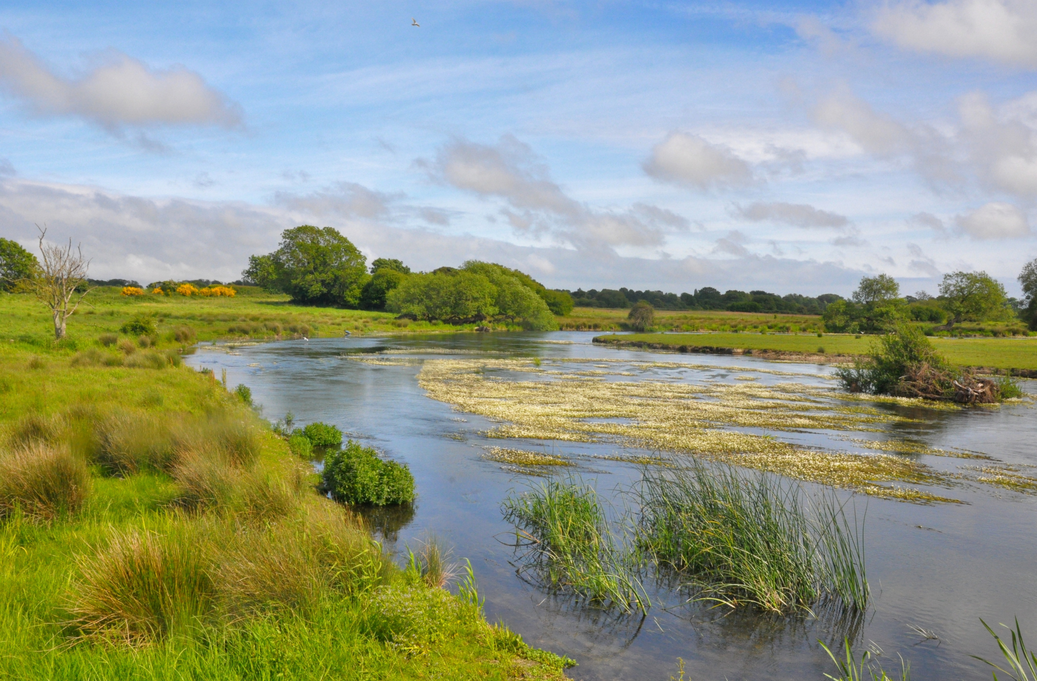
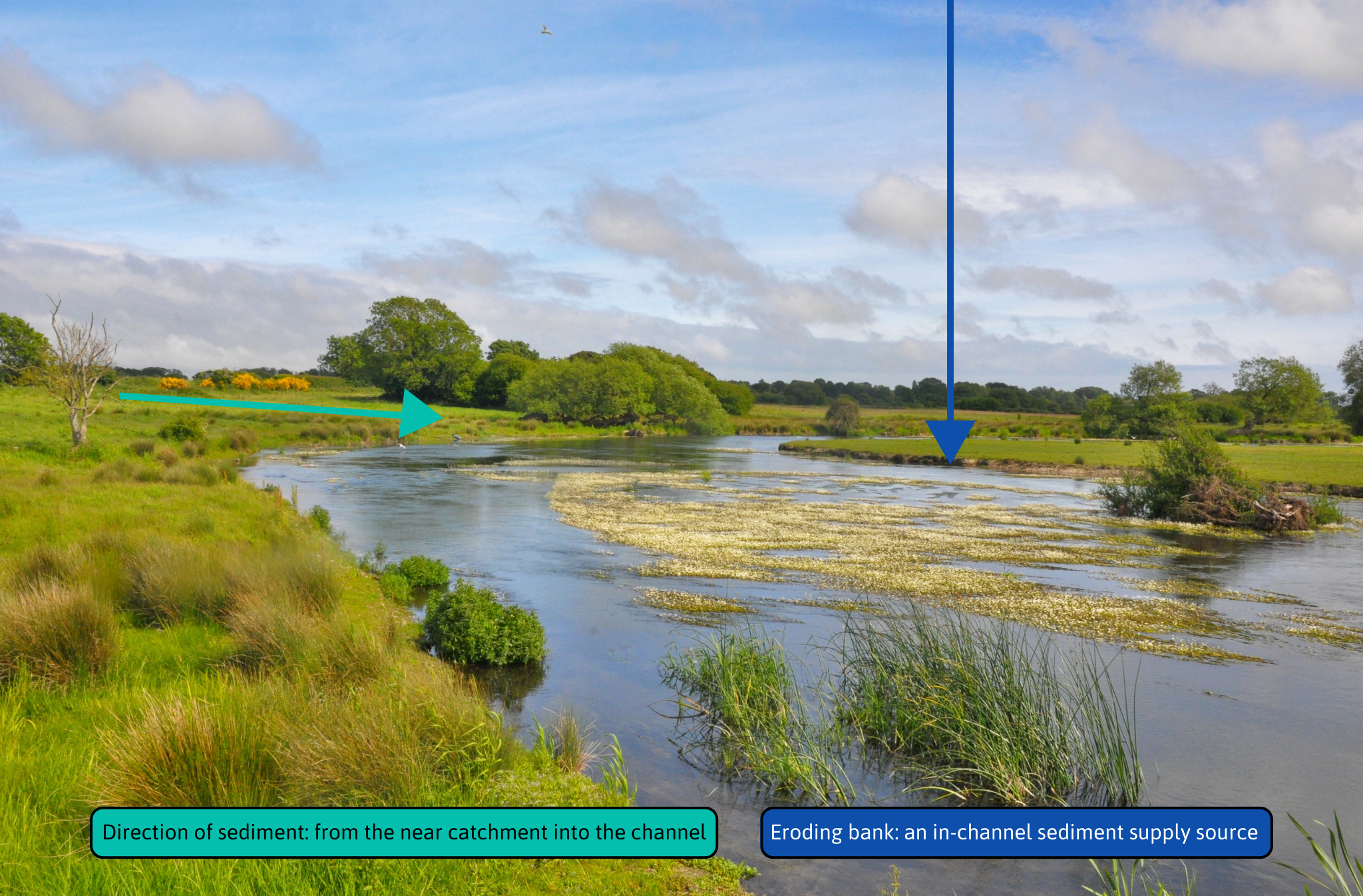
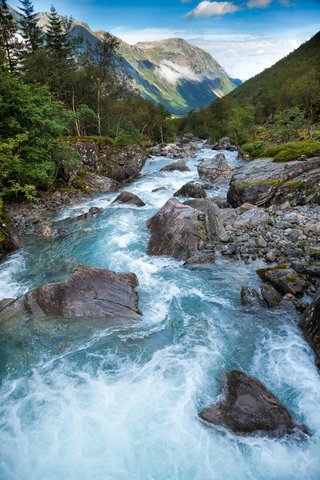
Task 1) Riverscape extremes in Britain
The two images below [1a & 1b] show a comparison between moorland and chalk river.
(#1a) An upland peaty burn in NW Scotland; (#1b) a lowland chalk river in S England. The Scottish riverscape might be considered natural but managed moorland now prevails where native birch/pine forest once grew, whilst post-glacial chalk rivers flowed in multiple channels through wet woodland. This highlights why calibrating 'departure from naturalness' is difficult in Britain because of a long historical legacy of land management.
Observation test: What is the most likely source and route of sediment supply?
Click through to view the photo with the answers revealed with arrows.
The quest for a credible, practical product
It is likely that our Holy Grail, in terms of scientific purity, will remain out of reach, but that doesn’t stop the quest for a credible, practical product. Over the past 30 odd years there has been enormous effort by various project groups here and abroad to try and develop a practical fieldwork method, linked to other approaches such as aerial photography and interpretation of old maps, and using well established geological and hydrological databases. Importantly, for quality control purposes, detailed photographic/video images during sampling allow subsequent expert verification and archived records for monitoring change.
Despite prodigious collective effort, the problems of scale, correct identification of a wide range of often-subtle features and the need for specialist expert interpretation of results intervene, meaning that physical aspects of river health require substantial skilled effort. Selecting and using diagnostic field and aerial photo data to interpret fluvial morphological processes is another aspect requiring specialist input. Vital to catchment process understanding are the influences of ‘memory’ in key drivers and ‘emergent phenomena’ in controlling channel/floodplain features and functions. It is these inescapable facts that determine the level and type of input by professional and citizen scientists (CS) alike and reduce the utility of more sophisticated ‘tech’.
Together with freshwater scientist Chris Mainstone, we provided advice to the OFWAT-funded citizen science river monitoring development project ‘CaSTCo’. Our advice was based on a ‘fitness of purpose’ assessment of a range of methods developed for physical habitat, and reaffirmed the over-riding need for quality assurance and control (https://castco.org/knowledge-base/overview-physical-habitat/).
Substantial professional-level support in terms of training and subsequent surveyor support is essential to ensure replicability and scientific credibility. Two CS-specific surveys (‘cRHS’ and ‘MoRPH’) (2,3) both recognise the need for professional input to QA (Quality Assurance) and QC (Quality Control), confirming there is no such thing as a stand-alone CS method, free at the point of delivery! Fitness for purpose is crucial to successful deployment of both professional and CS survey methods as it determines both the field sampling strategy and analytical interpretation of results needed for classifying the physical component of river health.
Task 2) Freedom to move
The three images below [2a, b & c] show a comparison of near-natural river, degraded and heavily modified river channels.
Observation test: Can you spot erosion and deposition-related habitat features?
Click through to view the photo with the answers revealed with arrows.
[NB: 2b & 2c have no arrows because they have been ‘denatured’]
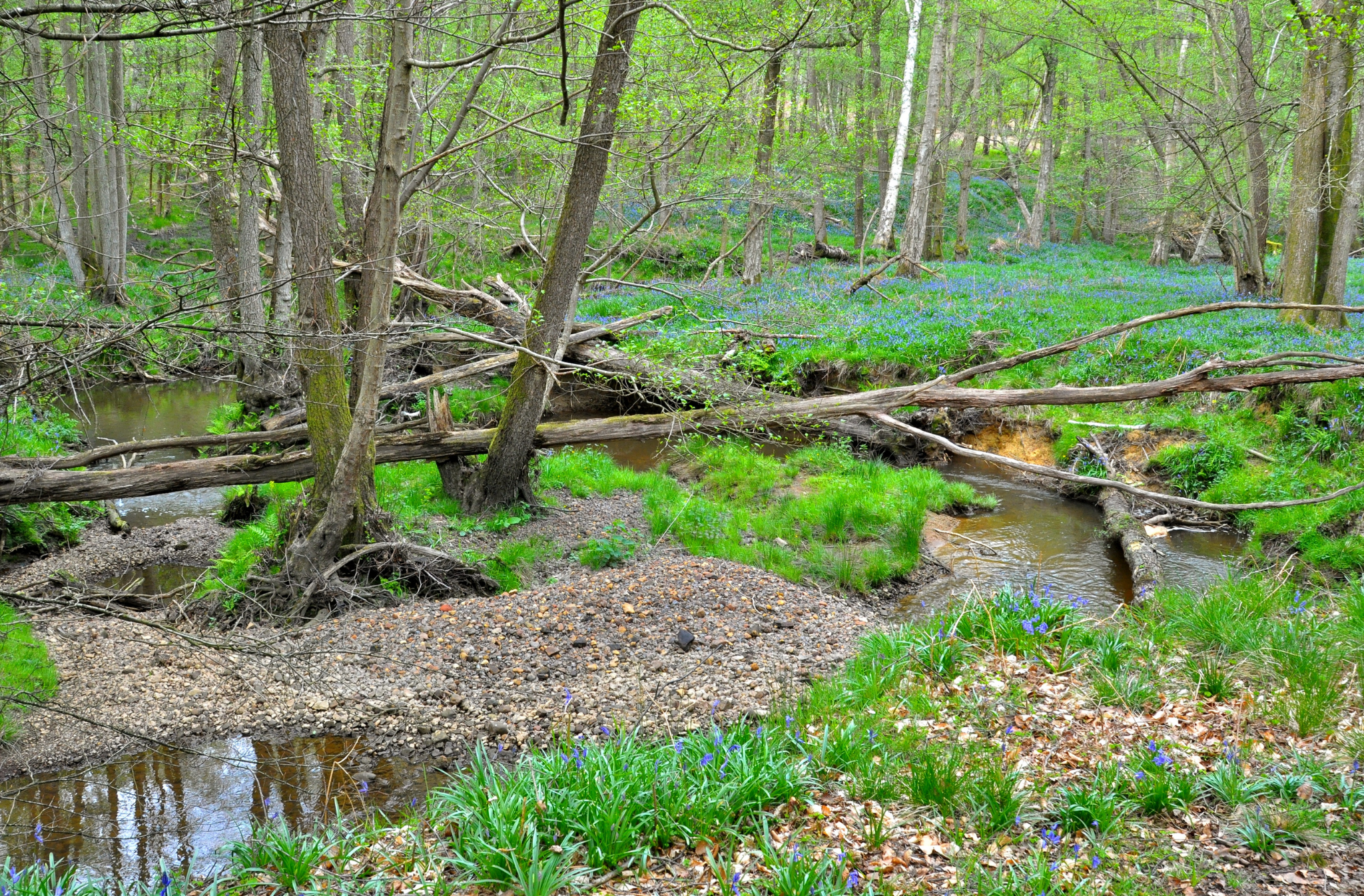
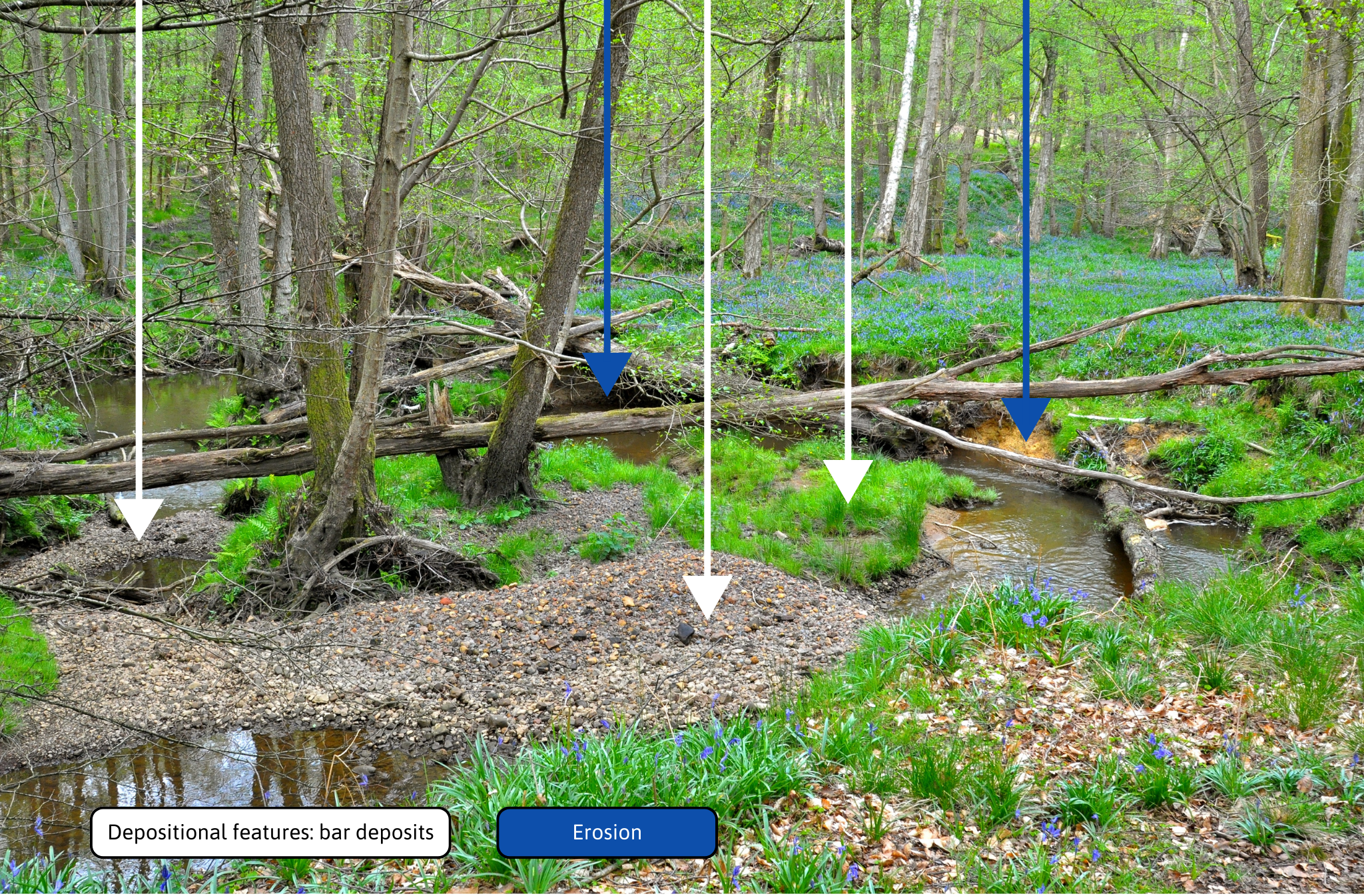
(#2a) Unconstrained fluvial processes produce a complex pattern of flow-types and associated riverbed and exposed sediment features. These create channel, riparian and floodplain habitats: aquatic vegetation, fallen trees and dead branch detritus are important contributors to the 'untidy' natural complexity.
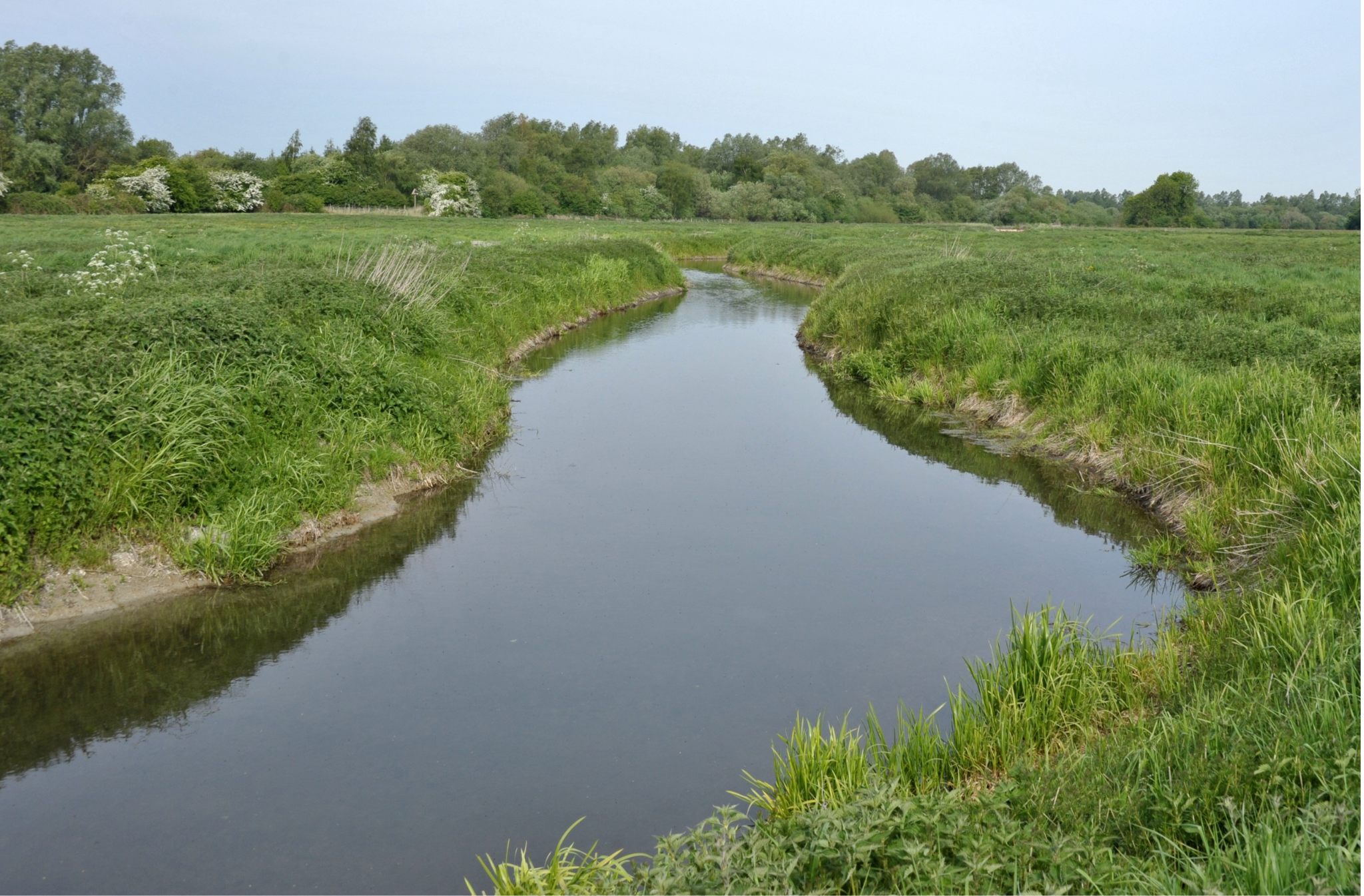
(#2b) Widened and straightened channels designed to reduce flooding are maintained by regular management; otherwise, the river would tend to re-meander and naturalise. Bank re-profiling, and field underdrainage, plus waterweed and tree removal create a 'tidy' uniform drainage channel devoid of flow and habitat complexity and wetland floodplain features.
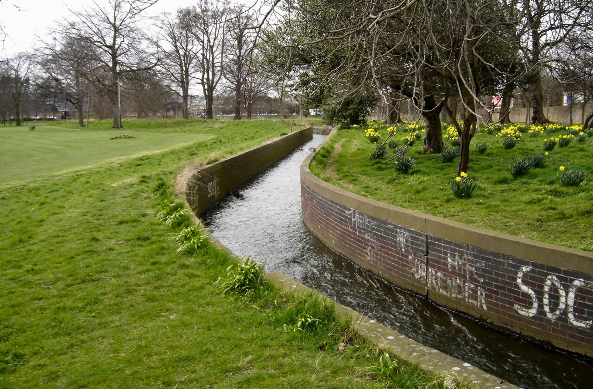
(#2c) A brick and concrete straitjacket effectively creates a glorified urban gutter, ushering water quickly away from vulnerable housing, industrial and transport infrastructure. As there is no local source of bank sediment to create natural instream morphological features, the river is artificial in both form and function.
Concluding comments
Despite our roles changing over time from enthusiastic practitioners to retired, interested onlookers, we remain convinced that catchment-scale river management is the key to effective protection and restoration of ecosystem functioning. Degradation of physical habitat and disruption of natural hydrological processes (‘hydromorphology’) are important contributory factors to the reasons why many rivers are failing to achieve ‘good ecological status’ as required by the WFD. A combination of snapshot sampling and river-length understanding of fluvial processes (walk-over knowledge) is required to identify the root causes and implement the most effective remedies within individual catchments. ‘Place-based’ projects may be ideal for CS engagement but for river restoration to be anchored at the reach scale they could be a mis-directed waste of effort.
All this river monitoring and management effort cannot occur without the collective expertise of professional river scientists, working together with citizen scientists who share a common purpose and can contribute invaluable local knowledge. The career pathway for maintaining and expanding professional science capacity within statutory and voluntary bodies must be education, starting at primary level and progressing through academia and practical outlets to provide an attractive and satisfying job prospect for experts and enthusiastic amateurs alike. ‘River science’ is sadly missing from the whole curriculum.
A range of professional (working and retired) scientists and amateur ‘activists’ is vitally important for protecting and restoring rivers, as are appropriate institutional advocates and hosts such as Rivers and Wildlife Trusts. The CaSTCo ‘roadmap’ (https://castco.org) advocates very careful collaborative actions for professional and citizen scientists, managed and monitored by environmental regulators to help our rivers recover from their current parlous state. That would be a worthwhile legacy, if not quite the Holy Grail of purists like us!!
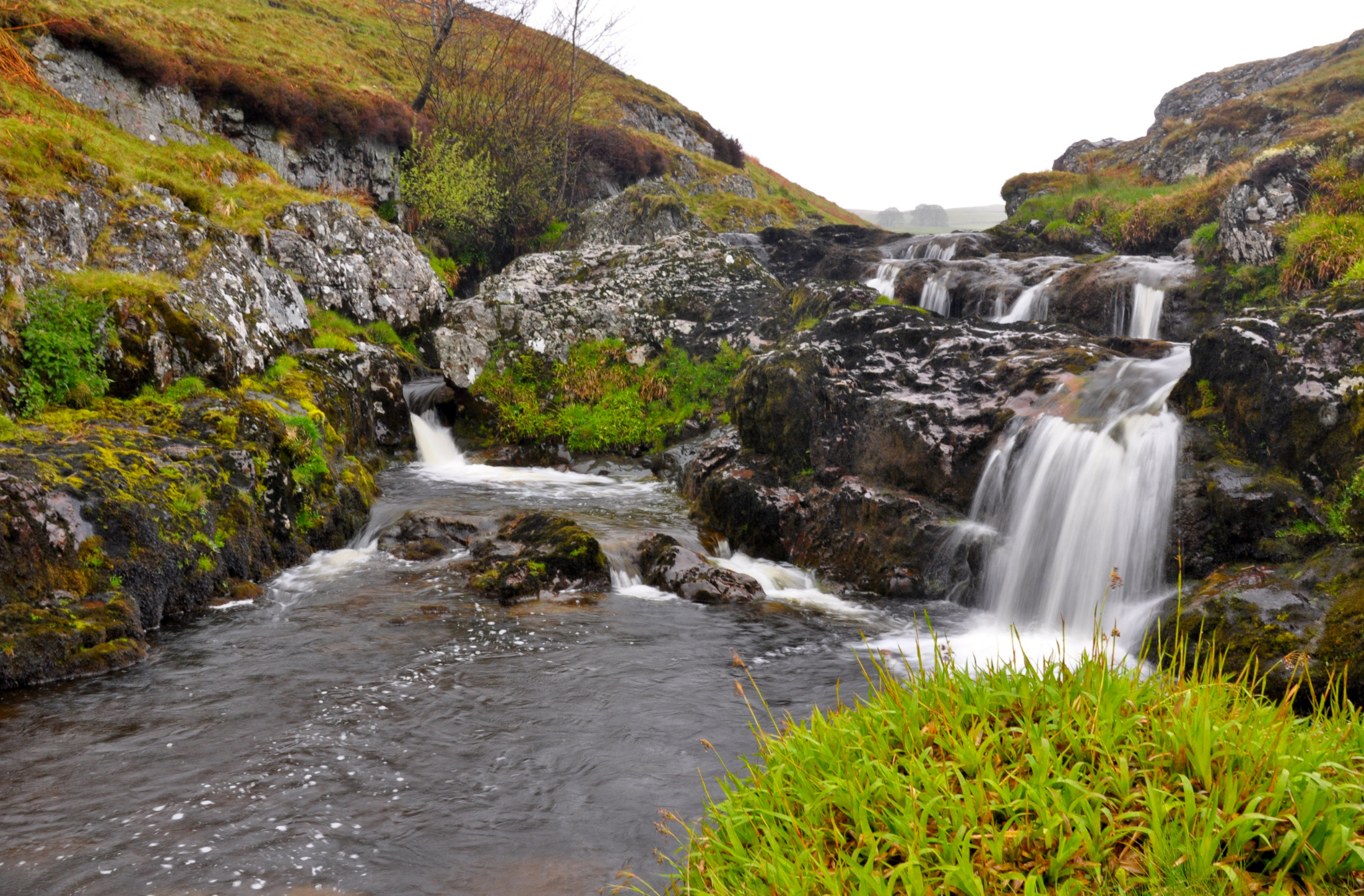
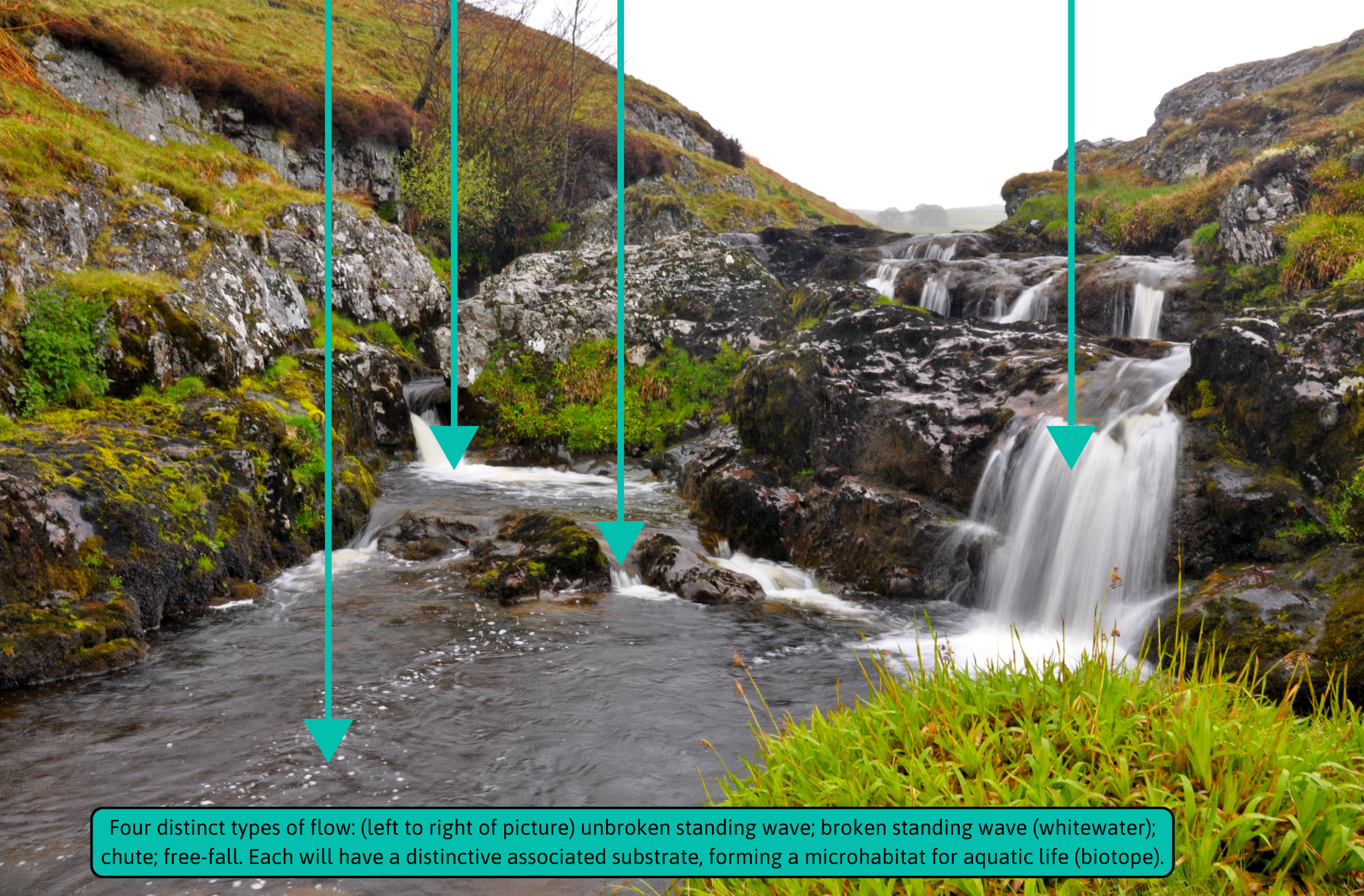
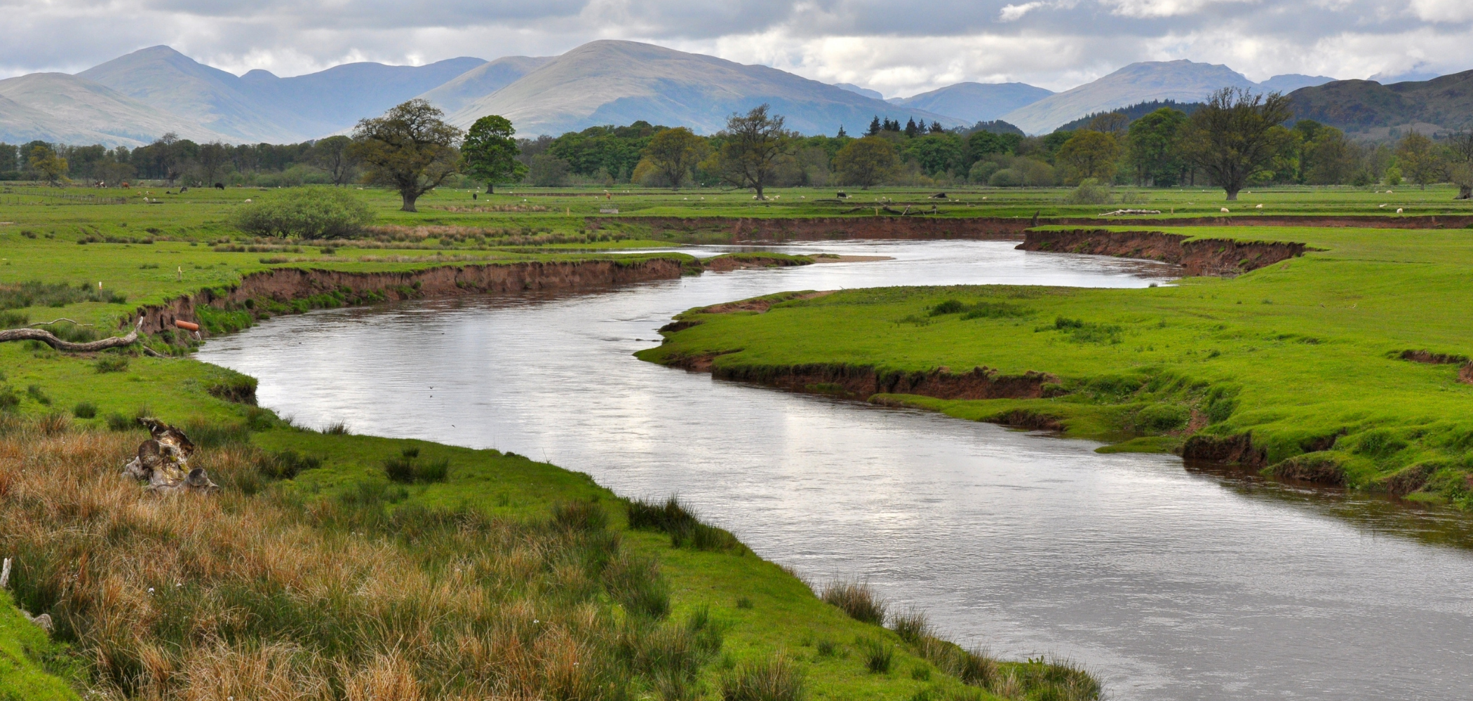
Task 3) Downstream changes in character
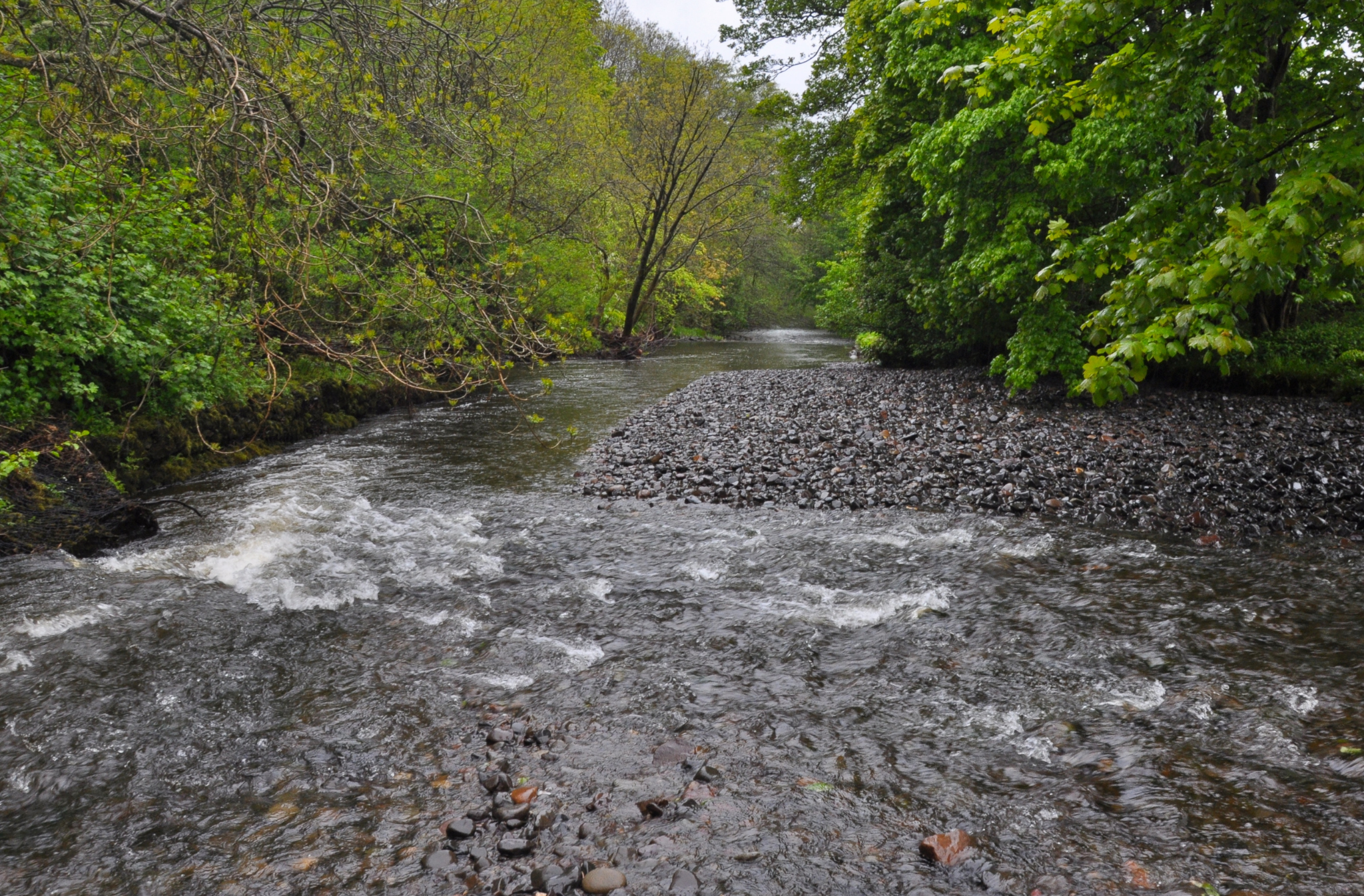
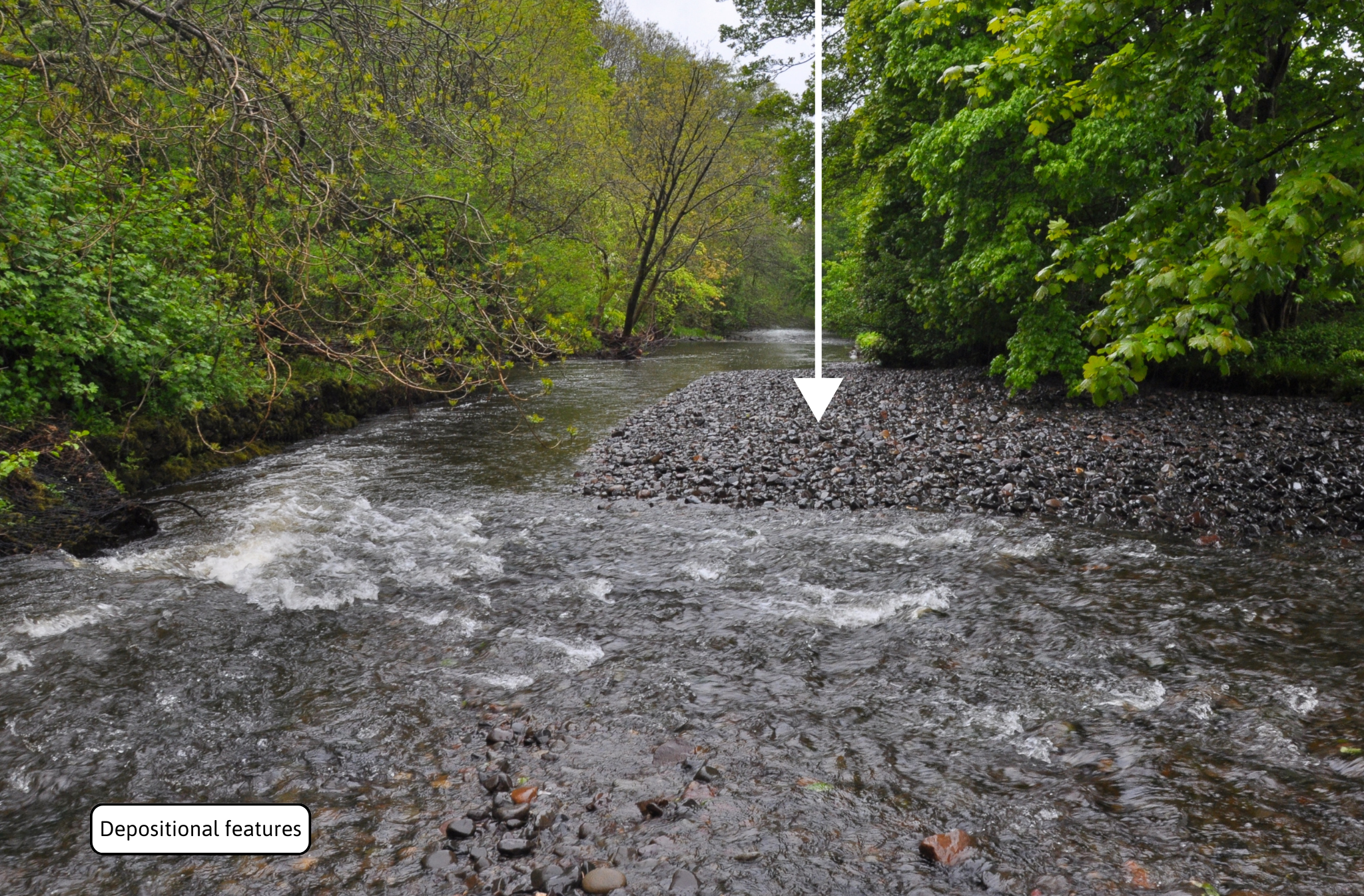
The three images below show a snapshot journey down the River Endrick; as a collection of 3a, b & c.
The River Endrick in Scotland changes character dramatically on its journey downstream: (#3a) cascading over bedrock in its upper reaches; (#3b) babbling along a tree-lined cobble-bed middle reach; and (#3c) meandering through floodplain pastureland in the lower reaches.
Downstream changes in river character depend on natural factors (e.g. geology, valley landform) and river management (see #2a-c); they certainly do not represent ‘youth’ ‘maturity’ and ‘old age’ as taught in the past! River-bed features provide clues to the type of journey that water and sediment take from source to mouth, but a snapshot approach provides only part of the story. The dynamic interaction of water and sediment shapes the river and determines its behaviour over its entire length (sources, pathways and sinks), as well as its local appearance, and defines how it will most likely respond to human intervention (good and bad) and climate change.
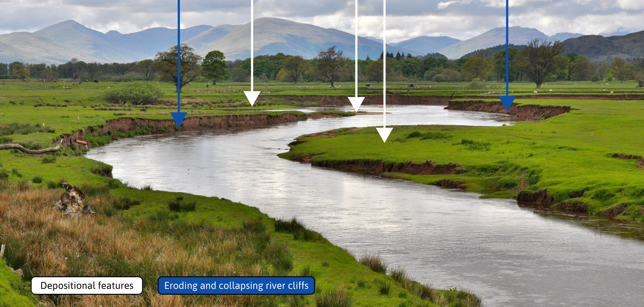
Observation test: On image 3a can you find four distinct types of flow?
Click through to view the photo with the answers revealed with arrows.
Observation test: On images 3b & 3c locate examples of erosion and/or deposition-related features.
Click through to view the photo with the answers revealed with arrows.

Interested in finding out more?
Rivers: A natural and not-so-natural history (British Wildlife Collection, 2018) by Nigel Holmes & Paul Raven is available to purchase online.
All photographs in this think piece appear in ‘Rivers’ and were taken by Nigel Holmes (1949-2014).
References
1. Newson, M & Raven, P (2026). Professional and citizen science to monitor and improve the physical habitat quality of rivers. Progress in Physical Geography, 50(1): 79-99. https://doi.org/10.1177/03091333251391047
2. The River Restoration Centre, cRHS Resources, with link to the cRHS Manual: https://www.therrc.co.uk/crhs-resources
3. Shuker, LJ, Gurnell, AM, Warton, G et al. (2017). MoRPH: a citizen science tool for monitoring and appraising physical habitat changes in rivers. Water and Environment Journal, 31: 418-424.
Recommended websites
CaSTCo (the Catchment Systems Thinking Cooperative): https://castco.org
The River Restoration Centre: https://www.therrc.co.uk
Further FBA reading
The Freshwater Biological Association publishes a wide range of books and offers a number of courses throughout the year. Check out our shop here.


Get involved
Our scientific research builds a community of action, bringing people and organisations together to deliver the urgent action needed to protect freshwaters. Join us in protecting freshwater environments now and for the future.